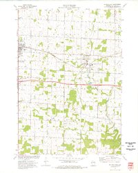
1974 Map of Baldwin East
USGS Topo · Published 1977About this map
The Chicago and North Western corridor defines the mid-1970s landscape of St. Croix County, connecting the bustling village of Baldwin with Woodville and the southern hamlet of Wildwood. This survey period captures a region in transition, where legacy infrastructure like the Old RR Gr and Old Railroad Grade sit adjacent to modern developments like the Sunset Memorial Gem Trailer Park. The local economy is visibly driven by numerous Gravel Pits and Quarries that dot the landscape between the Rush River and the Eau Galle River. Genealogists will find several well-established burial grounds, including Lone Pine Cem, Brookville Cem, and Peace Cem, alongside local spiritual centers like Christian Reformed and Immanuel Ch. The presence of several Townhall sites and the Radio Tower underscore the area's role as a decentralized civic hub during this era.
Find a feature on this map
29 named features on this map. Tap any name to fly to it.
Don’t see what you’re looking for? This feature index may not catch every label — zoom into the map to look around manually.
Map Details
Editions of this 1974 Baldwin East Map
This is the sole edition of this map. No revisions or reprints were ever made.
Other maps of this area

1946 · Knapp
USGS Topo · 1:62,500

1948 · Downing
USGS Topo · 1:62,500

1949 · Knapp
USGS Topo · 1:62,500

1949 · Baldwin
USGS Topo · 1:62,500

1950 · Downing
USGS Topo · 1:62,500

1950 · Deer Park
USGS Topo · 1:62,500

1953 · Saint Paul
USGS Topo · 1:250,000

1953 · Stillwater
USGS Topo · 1:250,000

1955 · Stillwater
USGS Topo · 1:250,000

1958 · Stillwater
USGS Topo · 1:250,000