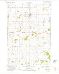
1974 Map of Baldwin West
USGS Topo · Published 1977About this map
Hammond and Baldwin serve as the primary hubs in this agricultural stretch of St. Croix County, where the Chicago and North Western railroad dictates the local orientation of industry and commerce. The landscape is defined by the winding courses of the Rush River and the Kinnickinnic River, which carve through the terrain near landmarks like Pine Knoll. Local life in the mid-1970s is evidenced by numerous rural institutions, including the Baldwin Christian Sch, Baptist Ch, and the Peace Ch. The presence of the Baldwin Landing Strip and various gravel pits suggests a mix of small-town infrastructure and resource extraction. A distinct network of named rural roads, such as Stagecoach Drive and Steeple Drive, connects these settlements across the townships of Hammond, Pleasant Valley, and Rush River.
Find a feature on this map
30 named features on this map. Tap any name to fly to it.
Don’t see what you’re looking for? This feature index may not catch every label — zoom into the map to look around manually.
Map Details
Editions of this 1974 Baldwin West Map
This is the sole edition of this map. No revisions or reprints were ever made.
Other maps of this area

1946 · River Falls
USGS Topo · 1:62,500

1948 · New Richmond
USGS Topo · 1:62,500

1949 · New Richmond
USGS Topo · 1:62,500

1949 · River Falls
USGS Topo · 1:62,500

1949 · Baldwin
USGS Topo · 1:62,500

1950 · Deer Park
USGS Topo · 1:62,500

1953 · Saint Paul
USGS Topo · 1:250,000

1953 · Stillwater
USGS Topo · 1:250,000

1955 · Stillwater
USGS Topo · 1:250,000

1958 · Stillwater
USGS Topo · 1:250,000