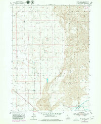
1955 Map of Baldy Knoll
USGS Topo · Published 1979About this map
The volcanic landscape of the Snake River Plain dominates this mid-century survey, defined by extensive Lava fields and a complex network of irrigation infrastructure. The settlement of Moreland sits at the southwestern edge of the quadrangle, serving as a gateway to the agricultural lands fed by the Aberdeen Canal, Peoples Canal, and Springfield Canal. These water systems represent the essential engineering required to transform the arid terrain into productive territory during this era of Idaho's development.
Find a feature on this map
13 named features on this map. Tap any name to fly to it.
Don’t see what you’re looking for? This feature index may not catch every label — zoom into the map to look around manually.
Map Details
Editions of this 1955 Baldy Knoll Map
2 editions found
Other maps of this area

1940 · Blackfoot
USGS Topo · 1:62,500

1943 · Blackfoot
USGS Topo · 1:62,500

1955 · Baldy Knoll
USGS Topo · 1:24,000

1955 · Rockford
USGS Topo · 1:24,000

1955 · Rose
USGS Topo · 1:24,000

1955 · Idaho Falls
USGS Topo · 1:250,000

1958 · Idaho Falls
USGS Topo · 1:250,000
1964 · Morgans Pasture NE
USGS Topo · 1:24,000
1971 · Blackfoot
USGS Topo · 1:24,000
1971 · Moreland
USGS Topo · 1:24,000