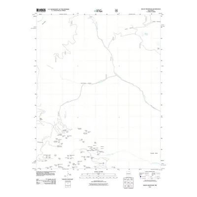
2011 Map of Baldy Mountain
USGS Topo · Published 2011About this map
Baldy Mountain and the surrounding high country of the Sangre de Cristo Range are defined here by an intense concentration of historical mining claims. The landscape is a dense network of prospect sites, including the French-Henry Mine, Deep Tunnel Mine, and Yellow Dog Group Mine, which cluster around French Henry Ridge. These labels reveal the massive scale of early extraction efforts in this pocket of New Mexico, where even minor operations like the Mountain Witch Mine and War Eagle Mine were formally recorded. Beyond the diggings, the terrain transitions into the broad expanse of Wilson Mesa and the drainage of Middle Ponil Creek. Remote outposts such as Beatty Cabin and geographic markers like Mills Divide provide reference points for researchers tracing the old access routes, such as F R 1910, that once connected these high-altitude camps to the world below.
Find a feature on this map
81 named features on this map. Tap any name to fly to it.
Don’t see what you’re looking for? This feature index may not catch every label — zoom into the map to look around manually.
Map Details
Editions of this 2011 Baldy Mountain Map
This is the sole edition of this map. No revisions or reprints were ever made.
Other maps of this area

1954 · Raton
USGS Topo · 1:250,000

1955 · Ute Park
USGS Topo · 1:62,500

1958 · Raton
USGS Topo · 1:250,000

1962 · Ash Mountain
USGS Topo · 1:62,500

1963 · Eagle Nest
USGS Topo · 1:24,000

1963 · Red River Pass
USGS Topo · 1:24,000

1963 · Comanche Point
USGS Topo · 1:24,000

1982 · Wheeler Peak
USGS Topo · 1:100,000
1986 · Van Bremmer Park
USGS Topo · 1:24,000
1986 · Ash Mountain
USGS Topo · 1:24,000