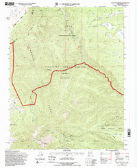
1995 Map of Baldy Mountain
USGS Topo · Published 1998About this map
Baldy Mountain dominates the southern landscape of this 1990s topographic survey, marking a high point in the Cimarron Range where the Philmont Scout Ranch and the Beaubien and Miranda Grant (Maxwell) converge. The map documents a rugged intersection of private grants and public lands, including the Valle Vidal Unit and the Elliot Barker State Wildlife Area. Industrial history is etched into the mountain's eastern slopes at the Aztec Mine and various prospects along Aztec Ridge, illustrating the era's mining legacy within the Sangre de Cristo Grant. Drainage patterns are clearly defined by South Ponil Creek and Greenwood Canyon, while localized landmarks like Mills Divide and Wilson Mesa provide essential orientation for this high-altitude terrain.
Find a feature on this map
26 named features on this map. Tap any name to fly to it.
Don’t see what you’re looking for? This feature index may not catch every label — zoom into the map to look around manually.
Map Details
Editions of this 1995 Baldy Mountain Map
This is the sole edition of this map. No revisions or reprints were ever made.
Other maps of this area

1954 · Raton
USGS Topo · 1:250,000

1955 · Ute Park
USGS Topo · 1:62,500

1958 · Raton
USGS Topo · 1:250,000

1962 · Ash Mountain
USGS Topo · 1:62,500

1963 · Eagle Nest
USGS Topo · 1:24,000

1963 · Red River Pass
USGS Topo · 1:24,000

1963 · Comanche Point
USGS Topo · 1:24,000

1982 · Wheeler Peak
USGS Topo · 1:100,000
1986 · Van Bremmer Park
USGS Topo · 1:24,000
1986 · Ash Mountain
USGS Topo · 1:24,000