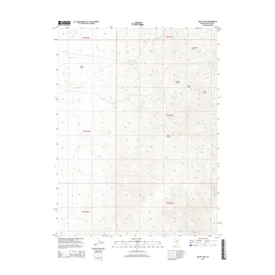
2014 Map of Baldy Peak
USGS Topo · Published 2014About this map
Antelope Range and its prominent Baldy Peak anchor this topographical study of eastern White Pine County. The landscape is defined by the transition from the high, arid peaks down into the western reach of Spring Valley. Water is the primary marker of life in this high-desert environment, with seasonal drainage systems such as Spring Valley Cr and Middle Cr carving paths through the terrain. The presence of numerous isolated water sources, including Middle Creek Spring, North Spring, and Tap Spring, indicates the traditional points of survival for livestock and early travelers in this portion of the Great Basin. Deep incisions in the eastern slopes, like Cottonwood Canyon and Secret Canyon, reveal a complex drainage network that channels snowmelt from the higher elevations of the range. This 2014 edition captures the region's sparse infrastructure, dominated by the land-grid boundaries of the t24n r67e and surrounding townships.
Find a feature on this map
21 named features on this map. Tap any name to fly to it.
Don’t see what you’re looking for? This feature index may not catch every label — zoom into the map to look around manually.
Map Details
Editions of this 2014 Baldy Peak Map
This is the sole edition of this map. No revisions or reprints were ever made.
Other maps of this area

1955 · Elko
USGS Topo · 1:250,000

1956 · Ely
USGS Topo · 1:250,000

1958 · Elko
USGS Topo · 1:250,000

1959 · Ely
USGS Topo · 1:250,000

1962 · Elko
USGS Topo · 1:250,000

1963 · Ely
USGS Topo · 1:250,000

1965 · Elko
USGS Topo · 1:250,000

1979 · Sunset Reservoir
USGS Topo · 1:24,000

1982 · Chin Creek Spring
USGS Topo · 1:24,000
1982 · Becky Peak
USGS Topo · 1:24,000