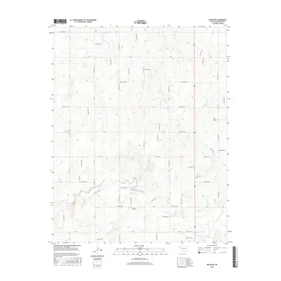
2016 Map of Balko NE
USGS Topo · Published 2016About this map
The High Plains of Beaver County are defined here by a network of seasonal watercourses and hollows that break the flat horizon of the Oklahoma Panhandle. The drainages of North Fork Clear Creek and S Fork Clear Cr converge in the southern portion of the map, carving distinct relief into the landscape. This area maintains its rural character through a grid of section-line roads, including NS-138 and Ew-25, which connect isolated landmarks. Cultural sites like Busch Chapel and its adjacent Busch Chapel Cem provide vital links to the area's pioneer heritage. Further west, Capitol View Cem sits above the creek forks, offering a quiet record of the families who settled this part of the High Plains. The landscape is also marked by numerous named hollows such as Hollow E0200 and Hollow N1360, which follow the natural contours and drainage patterns that have historically shaped local ranching and agriculture.
Find a feature on this map
62 named features on this map. Tap any name to fly to it.
Don’t see what you’re looking for? This feature index may not catch every label — zoom into the map to look around manually.
Map Details
Editions of this 2016 Balko NE Map
This is the sole edition of this map. No revisions or reprints were ever made.
Other maps of this area

1954 · Perryton
USGS Topo · 1:250,000

1958 · Perryton
USGS Topo · 1:250,000

1971 · Clear Lake NW
USGS Topo · 1:24,000

1971 · Clear Lake SW
USGS Topo · 1:24,000
1971 · Mocane SW
USGS Topo · 1:24,000

1973 · Balko
USGS Topo · 1:24,000

1973 · Balko NE
USGS Topo · 1:24,000

1973 · Elmwood
USGS Topo · 1:24,000

1973 · Floris
USGS Topo · 1:24,000

1973 · Beaver
USGS Topo · 1:24,000