
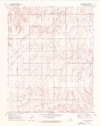
1971 Map of Clear Lake SW
USGS Topo · Published 1973About this map
Elmwood and Logan anchor this High Plains landscape during the early 1970s, where the undulating terrain of Beaver County is carved by Duck Creek, Coon Creek, and Kiowa Creek. The map reveals a rural community deeply rooted in the land, evidenced by several local landmarks like Garrett Sch and the South Flat Ch. This era was defined by significant energy development, with a dense network of pipelines and countless Oil Wells and Gas Wells spanning the region. Genealogists will find value in the location of the Baker Cem and Sophia Cem, while the local topography is marked by notable rises like Mountain View. The presence of numerous Drill Holes and gravel pits suggests a landscape in constant flux between agricultural heritage and industrial utility.
Find a feature on this map
22 named features on this map. Tap any name to fly to it.
Don’t see what you’re looking for? This feature index may not catch every label — zoom into the map to look around manually.
Map Details
Editions of this 1971 Clear Lake SW Map
2 editions found
Other maps of this area

1954 · Perryton
USGS Topo · 1:250,000

1958 · Perryton
USGS Topo · 1:250,000

1971 · Clear Lake NW
USGS Topo · 1:24,000

1971 · Clear Lake
USGS Topo · 1:24,000

1971 · Clear Lake SE
USGS Topo · 1:24,000

1972 · Darrouzett
USGS Topo · 1:24,000

1972 · Gaylord
USGS Topo · 1:24,000

1973 · Booker
USGS Topo · 1:24,000

1973 · Balko NE
USGS Topo · 1:24,000

1973 · Elmwood
USGS Topo · 1:24,000