
1971 Map of Clear Lake
USGS Topo · Published 1973About this map
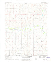
The High Plains of the Oklahoma Panhandle define this 1971 survey, centered on the drainage systems of Duck Pond Creek and Mexico Creek. In the early 1970s, the landscape of Beaver County was a functional mix of ranching and industrial extraction, dominated by numerous Gas Wells and Oil Wells. The small, eponymous Clear Lake sits in the eastern portion of the quadrangle, while the presence of a Landing Strip, Radio Tower, and Sewage Disposal Pond suggests a hub of local activity and infrastructure near the Benton and Logan township lines. For the local historian or genealogist, the map identifies specific resource extraction sites including a Caliche Pit, Clay Pit, and Gravel Pit, providing a clear view of the area's geological and economic priorities before modern developments altered the surface landscape.
Find a feature on this map
19 named features on this map. Tap any name to fly to it.
Don’t see what you’re looking for? This feature index may not catch every label — zoom into the map to look around manually.
Map Details
Editions of this 1971 Clear Lake Map
This is the sole edition of this map. No revisions or reprints were ever made.
Other maps of this area

1954 · Perryton
USGS Topo · 1:250,000

1958 · Perryton
USGS Topo · 1:250,000

1970 · Knowles
USGS Topo · 1:24,000

1970 · Mocane SE
USGS Topo · 1:24,000

1971 · Clear Lake NW
USGS Topo · 1:24,000

1971 · Clear Lake SW
USGS Topo · 1:24,000

1971 · Clear Lake SE
USGS Topo · 1:24,000

1971 · Logan
USGS Topo · 1:24,000

1971 · Logan NW
USGS Topo · 1:24,000
1971 · Mocane SW
USGS Topo · 1:24,000