
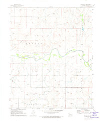
1971 Map of Clear Lake NW
USGS Topo · Published 1973About this map
The High Plains of Beaver County, Oklahoma, are defined by an extensive network of natural gas extraction infrastructure in this 1971 survey. The landscape of Elmwood, Benton, and Logan townships is punctuated by dozens of Gas Wells, indicating the region's intensive energy development during the early 1970s. This industrial layer is superimposed over a natural drainage system where Clear Creek and Cottonwood Creek meander through the northwestern portion of the quadrangle, while Duck Pond Creek and Camp Creek carve paths through the eastern sections. Apart from the energy sector, represented by numerous Drill Holes and Pipelines, the map records several Gravel Pits and a solitary Oil Well, illustrating the subterranean economy that drove the development of this Panhandle region. The section lines and fence lines create a rigid grid across the undulating terrain, typical of the rural land management in this part of the state.
Find a feature on this map
14 named features on this map. Tap any name to fly to it.
Don’t see what you’re looking for? This feature index may not catch every label — zoom into the map to look around manually.
Map Details
Editions of this 1971 Clear Lake NW Map
This is the sole edition of this map. No revisions or reprints were ever made.
Other maps of this area

1954 · Perryton
USGS Topo · 1:250,000

1958 · Perryton
USGS Topo · 1:250,000

1970 · Mocane SE
USGS Topo · 1:24,000

1971 · Clear Lake SW
USGS Topo · 1:24,000

1971 · Clear Lake
USGS Topo · 1:24,000

1971 · Clear Lake SE
USGS Topo · 1:24,000
1971 · Mocane SW
USGS Topo · 1:24,000

1973 · Balko NE
USGS Topo · 1:24,000

1973 · Elmwood
USGS Topo · 1:24,000

1973 · Beaver
USGS Topo · 1:24,000