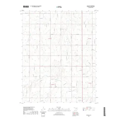
2018 Map of Balko NE
USGS Topo · Published 2018About this map
The High Plains of Beaver County are defined by the intricate dendritic drainage of the North Canadian River watershed, as seen in the various branches of Clear Creek. North Fork Clear Creek and the S Fork Clear Cr converge in the southern half of this landscape, carving deep coulees into the Oklahoma Panhandle. Small family and community landmarks like Capitol View Cem and Busch Chapel Cem sit atop the plateaus, preserving the early 20th-century history of local settlement. The terrain is marked by a strict section-line road grid, including routes like Ew-19 and Ew-24, which navigate the steep breaks where streams like Cottonwood Cr and Home Cr have eroded the landscape. This pattern of land use reflects the enduring agricultural and ranching heritage of the region, where roads are forced to adapt to the natural topography of the creek beds.
Find a feature on this map
38 named features on this map. Tap any name to fly to it.
Don’t see what you’re looking for? This feature index may not catch every label — zoom into the map to look around manually.
Map Details
Editions of this 2018 Balko NE Map
This is the sole edition of this map. No revisions or reprints were ever made.
Other maps of this area

1954 · Perryton
USGS Topo · 1:250,000

1958 · Perryton
USGS Topo · 1:250,000

1971 · Clear Lake NW
USGS Topo · 1:24,000

1971 · Clear Lake SW
USGS Topo · 1:24,000
1971 · Mocane SW
USGS Topo · 1:24,000

1973 · Balko
USGS Topo · 1:24,000

1973 · Balko NE
USGS Topo · 1:24,000

1973 · Elmwood
USGS Topo · 1:24,000

1973 · Floris
USGS Topo · 1:24,000

1973 · Beaver
USGS Topo · 1:24,000