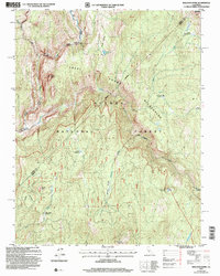
2004 Map of Balloon Dome
USGS Topo · Published 2007About this map
Balloon Dome stands as the central landmark of this high-elevation landscape, where the San Joaquin River and its South Fork carve deep through the Sierra Nevada. The map documents a strictly preserved environment, split between the Ansel Adams Wilderness and the John Muir Wilderness within the Sierra National Forest. The absence of modern roads highlights the reliance on primitive infrastructure like the Cassidy Bridge and Lower Miller Crossing to navigate the steep drainage systems. A network of high-altitude meadows, including Cassidy Meadows, Bear Meadow, and Cow Meadow, suggests a history of seasonal grazing or early pack-trail camps. Notable summits such as Mount Tom and Brown Cone overlook remote water bodies like Rattlesnake Lake and the Crater Lake Meadow area.
Find a feature on this map
36 named features on this map. Tap any name to fly to it.
Don’t see what you’re looking for? This feature index may not catch every label — zoom into the map to look around manually.
Map Details
Editions of this 2004 Balloon Dome Map
This is the sole edition of this map. No revisions or reprints were ever made.
Other maps of this area

1901 · Mt. Lyell
USGS Topo · 1:125,000

1904 · Kaiser
USGS Topo · 1:125,000

1947 · Mariposa
USGS Topo · 1:250,000

1948 · Mariposa
USGS Topo · 1:250,000

1953 · Merced Peak
USGS Topo · 1:62,500

1953 · Devils Postpile
USGS Topo · 1:62,500

1953 · Shuteye Peak
USGS Topo · 1:62,500

1953 · Kaiser Peak
USGS Topo · 1:62,500

1957 · Mariposa
USGS Topo · 1:250,000

1963 · Mariposa
USGS Topo · 1:250,000