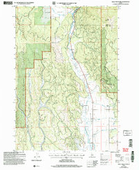
2004 Map of Bally Mountain
USGS Topo · Published 2007About this map
The New Meadows Ranger District encompasses the varied terrain where the Little Salmon River cuts through the high country of the Payette National Forest. This landscape is defined by the transition between the broad, flat basins of Round Valley and Meadows Valley and the steep slopes leading toward Bally Mountain. The mapping reveals a rural infrastructure built around water management and timber access, featuring the Campbell Ditch and Brown Creek Road. Local industry and land use are represented by a Gravel Pit and the notable Circle C Ranch, situated near the confluence of Sixmile Creek and Martin Creek. The presence of Hot Springs along the river valley suggests the geothermal activity common to this central Idaho region, serving as a landmark for early travelers and residents alike.
Find a feature on this map
23 named features on this map. Tap any name to fly to it.
Don’t see what you’re looking for? This feature index may not catch every label — zoom into the map to look around manually.
Map Details
Editions of this 2004 Bally Mountain Map
This is the sole edition of this map. No revisions or reprints were ever made.
Other maps of this area

1911 · Meadows
USGS Topo · 1:125,000

1938 · Riggins
USGS Topo · 1:96,000

1945 · Riggins
USGS Topo · 1:125,000

1954 · New Meadows
USGS Topo · 1:62,500

1955 · Baker
USGS Topo · 1:250,000

1955 · Grangeville
USGS Topo · 1:250,000

1959 · Baker
USGS Topo · 1:250,000

1959 · Grangeville
USGS Topo · 1:250,000

1963 · Bally Mountain
USGS Topo · 1:24,000

1963 · Indian Mountain
USGS Topo · 1:24,000