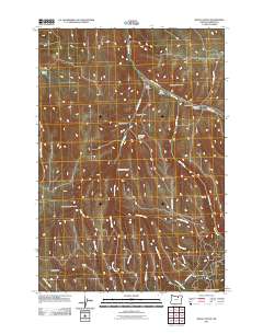
2011 Map of Balm Canyon
USGS Topo · Published 2011About this map
Rhea Creek carves a significant path through this portion of Morrow County, accompanied by a network of drainage systems that define the local topography. The presence of the Rhea Creek Cemetery near Upper Rhea Creek Rd offers a focal point for genealogical interest in an area otherwise characterized by its namesake Balm Canyon and numerous deep draws. The landscape is a complex of named canyons and gulches, including the starkly named Graveyard Canyon, Lunceford Canyon, and Horse Gulch. In the southern reaches, higher elevations like Warm Hill overlook a confluence of seasonal streams such as Houselog Creek and Thorn Creek. This survey illustrates the traditional rural infrastructure of the region, where travel is dictated by the natural corridors of Road Canyon Rd and winding creek beds.
Find a feature on this map
28 named features on this map. Tap any name to fly to it.
Don’t see what you’re looking for? This feature index may not catch every label — zoom into the map to look around manually.
Map Details
Editions of this 2011 Balm Canyon Map
This is the sole edition of this map. No revisions or reprints were ever made.
Other maps of this area

1953 · Pendleton
USGS Topo · 1:250,000

1956 · Pendleton
USGS Topo · 1:250,000

1968 · Ruggs
USGS Topo · 1:24,000

1968 · Heppner
USGS Topo · 1:24,000

1968 · Skinners Fork
USGS Topo · 1:24,000

1969 · Summerfield Ridge
USGS Topo · 1:24,000

1969 · Chapin Creek
USGS Topo · 1:24,000

1969 · Madison Butte
USGS Topo · 1:24,000

1969 · Hardman
USGS Topo · 1:24,000

1969 · Big Rock Flat
USGS Topo · 1:24,000