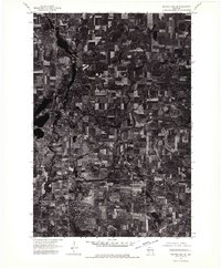
1974 Map of Balsam Lake SE
USGS Topo · Published 1976About this map
Amery stands as a primary hub within this orthophotoquad, which was developed from aerial photography captured in late 1974. The imagery provides a clear look at the agricultural patterns and waterway systems that define this part of Polk County, showing the concentration of development in the northwestern portion of the sheet. Further south, the map details the layout of Clear Lake, showing its position within the broader rural landscape. Unlike traditional line-drawn topographic maps, this photographic survey reveals the precise textures of the Wisconsin woodlots, wetlands, and cultivated fields, offering a high-fidelity record of land use and property boundaries as they existed in the mid-1970s.
Find a feature on this map
2 named features on this map. Tap any name to fly to it.
Don’t see what you’re looking for? This feature index may not catch every label — zoom into the map to look around manually.
Map Details
Editions of this 1974 Balsam Lake SE Map
This is the sole edition of this map. No revisions or reprints were ever made.
Other maps of this area

1948 · Downing
USGS Topo · 1:62,500

1950 · Downing
USGS Topo · 1:62,500

1950 · Deer Park
USGS Topo · 1:62,500

1950 · Balsam Lake
USGS Topo · 1:62,500

1950 · Turtle Lake
USGS Topo · 1:62,500

1952 · Turtle Lake
USGS Topo · 1:62,500

1953 · Stillwater
USGS Topo · 1:250,000

1955 · Stillwater
USGS Topo · 1:250,000

1958 · Stillwater
USGS Topo · 1:250,000

1965 · Stillwater
USGS Topo · 1:250,000