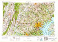
1957 Map of Baltimore
USGS Topo · Published 1964About this map
The Baltimore metropolitan area and the northern Chesapeake Bay dominate this mid-century regional survey, showing the complex intersection of maritime commerce, military infrastructure, and industrial rail lines. The landscape is anchored by massive installations like the Aberdeen Proving Ground, Fort George G Meade Military Reservation, and the Bainbridge Naval Training Center. To the west, the topography rises toward the Blue Ridge and South Mountain, where the Gettysburg National Military Park preserves the fields of the Civil War. Major transportation corridors, including the Pennsylvania RR and the newly developed Baltimore-Washington Parkway, illustrate the post-war growth connecting Silver Spring and Bethesda to the urban core. The map traces the winding courses of the Susquehanna River and Potomac River, highlighting the region's reliance on these primary waterways for both boundary definition and heavy industry.
Find a feature on this map
69 named features on this map. Tap any name to fly to it.
Don’t see what you’re looking for? This feature index may not catch every label — zoom into the map to look around manually.
Map Details
Editions of this 1957 Baltimore Map
5 editions found

Other maps of this area

1884 · Harpers Ferry
USGS Topo · 1:125,000

1890 · Mt. Vernon
USGS Topo · 1:125,000

1891 · Harpers Ferry
USGS Topo · 1:125,000

1891 · Mt. Vernon
USGS Topo · 1:125,000

1892 · Laurel
USGS Topo · 1:62,500

1892 · Ellicott
USGS Topo · 1:62,500

1892 · Owensville
USGS Topo · 1:62,500

1892 · Annapolis
USGS Topo · 1:62,500

1893 · North Point
USGS Topo · 1:62,500

1893 · Gunpowder
USGS Topo · 1:62,500