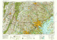
1957 Map of Baltimore
USGS Topo · Published 1979About this map
Baltimore and its surrounding Mid-Atlantic corridor appear here during a period of significant suburban expansion and industrial activity. This survey captures the massive footprint of the Aberdeen Proving Ground and Fort George G Meade Military Reservation, alongside the early development of planned communities like Columbia. The regional transport network is dominated by the Pennsylvania RR and the Baltimore & Ohio RR, which parallel the Chesapeake Bay and the Potomac River.
Find a feature on this map
69 named features on this map. Tap any name to fly to it.
Don’t see what you’re looking for? This feature index may not catch every label — zoom into the map to look around manually.
Map Details
Editions of this 1957 Baltimore Map
5 editions found

Other maps of this area

1884 · Harpers Ferry
USGS Topo · 1:125,000

1890 · Mt. Vernon
USGS Topo · 1:125,000

1891 · Harpers Ferry
USGS Topo · 1:125,000

1891 · Mt. Vernon
USGS Topo · 1:125,000

1892 · Laurel
USGS Topo · 1:62,500

1892 · Ellicott
USGS Topo · 1:62,500

1892 · Owensville
USGS Topo · 1:62,500

1892 · Annapolis
USGS Topo · 1:62,500

1893 · North Point
USGS Topo · 1:62,500

1893 · Gunpowder
USGS Topo · 1:62,500