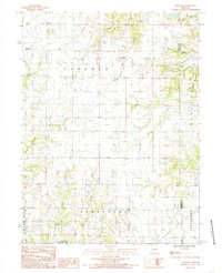
1984 Map of Bancroft
USGS Topo · Published 1985About this map
Bancroft serves as the primary landmark in this mid-1980s landscape at the boundary of Lincoln and Jefferson townships. The terrain is defined by a dense network of drainages that feed toward the Grand River in the southwest corner of the map. Tracing the courses of Brushy Creek, Pilot Grove Creek, and the East Fork, the map illustrates a rural Missouri landscape where section-line roads and scattered farmsteads follow the ridges between deep hollows. The eastern portion of the sheet is notable for the Daviess Co Grundy Co line, which cuts through the winding path of Raccoon Creek. Near the southern boundary, the Jamesport Community Lake provides a clear marker for local recreational history, while several small unmarked Cem sites hint at the long-standing family settlements that once dotted these hillsides.
Find a feature on this map
22 named features on this map. Tap any name to fly to it.
Don’t see what you’re looking for? This feature index may not catch every label — zoom into the map to look around manually.
Map Details
Editions of this 1984 Bancroft Map
This is the sole edition of this map. No revisions or reprints were ever made.
Other maps of this area

1921 · Chillicothe
USGS Topo · 1:62,500

1922 · Gallatin
USGS Topo · 1:62,500

1923 · Chillicothe
USGS Topo · 1:62,500

1925 · Gilman
USGS Topo · 1:62,500

1946 · Gilman
USGS Topo · 1:48,000

1948 · Gilman
USGS Topo · 1:62,500

1948 · Trenton
USGS Topo · 1:62,500

1953 · Moberly
USGS Topo · 1:250,000

1954 · Centerville
USGS Topo · 1:250,000

1954 · Moberly
USGS Topo · 1:250,000