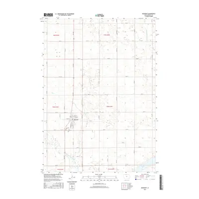
2015 Map of Bancroft
USGS Topo · Published 2015About this map
Bancroft serves as the primary hub of this North Central Iowa landscape, situated where the grid of rural township roads meets a network of local streets such as W Ramsey St and E Grove St. The town's historical foundations are marked by Greenwood Cem and Saint Johns Cem on its southern edge, providing significant points of interest for genealogical research. The terrain is defined by the wandering path of Mud Cr, which meanders southeastward through the prairie towards the East Fork Des Moines River. In the southeastern corner, the Smith Pool and Drainage Ditch Number 80 reflect the region's managed water systems and low-lying topography. This survey captures the structured agricultural layout of Kossuth County, where the township boundaries of t98n r29w and t98n r28w meet, illustrating the intersection of natural waterways and human engineering.
Find a feature on this map
33 named features on this map. Tap any name to fly to it.
Don’t see what you’re looking for? This feature index may not catch every label — zoom into the map to look around manually.
Map Details
Editions of this 2015 Bancroft Map
This is the sole edition of this map. No revisions or reprints were ever made.
Other maps of this area

1954 · Fairmont
USGS Topo · 1:250,000

1958 · Fairmont
USGS Topo · 1:250,000

1972 · German Valley
USGS Topo · 1:24,000

1972 · Bancroft
USGS Topo · 1:24,000

1972 · Titonka
USGS Topo · 1:24,000

1972 · Burt
USGS Topo · 1:24,000

1972 · Ledyard
USGS Topo · 1:24,000
1972 · Lakota
USGS Topo · 1:24,000

1980 · Lone Rock
USGS Topo · 1:24,000

1980 · Swea City
USGS Topo · 1:24,000