
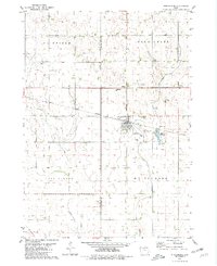
1980 Map of Lone Rock
USGS Topo · Published 1980About this map
Lone Rock serves as the primary hub in this agricultural landscape of Kossuth County, characterized by a complex network of waterways and drainage improvements. The land is defined by the winding paths of Black Cat Creek and Calamus Creek, which are supplemented by engineered waterways like Ditch No 69 and Ditch No 63, reflecting the mid-century intensification of farming in northern Iowa. Rural social life is anchored by locations such as Immanuel Ch, Good Hope Ch, and a standalone Townhall near the southern boundary.
Find a feature on this map
16 named features on this map. Tap any name to fly to it.
Don’t see what you’re looking for? This feature index may not catch every label — zoom into the map to look around manually.
Map Details
Editions of this 1980 Lone Rock Map
This is the sole edition of this map. No revisions or reprints were ever made.
Other maps of this area

1954 · Fairmont
USGS Topo · 1:250,000

1958 · Fairmont
USGS Topo · 1:250,000

1972 · Algona
USGS Topo · 1:24,000

1972 · Bancroft
USGS Topo · 1:24,000

1972 · Burt
USGS Topo · 1:24,000

1980 · Fenton
USGS Topo · 1:24,000

1980 · Seneca
USGS Topo · 1:24,000

1980 · Armstrong SE
USGS Topo · 1:24,000

1980 · Hobarton
USGS Topo · 1:24,000
1980 · Whittemore
USGS Topo · 1:24,000