
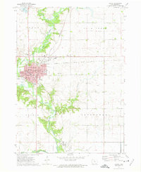
1972 Map of Algona
USGS Topo · Published 1975About this map
The East Fork Des Moines River winds through the heart of Kossuth County, defining the western edge of Algona and the small settlement of Irvington. In the early 1970s, this area served as a significant regional hub, anchored by the Courthouse and a dense network of local institutions. The town's educational landscape is particularly detailed, featuring St Cecelias Academy, Garrigan High Sch, and several neighborhood schools like Bryant Sch and Wallace Sch.
Find a feature on this map
38 named features on this map. Tap any name to fly to it.
Don’t see what you’re looking for? This feature index may not catch every label — zoom into the map to look around manually.
Map Details
Editions of this 1972 Algona Map
2 editions found
Other maps of this area

1954 · Fairmont
USGS Topo · 1:250,000

1954 · Fort Dodge
USGS Topo · 1:250,000

1957 · Fort Dodge
USGS Topo · 1:250,000

1958 · Fort Dodge
USGS Topo · 1:250,000

1958 · Fairmont
USGS Topo · 1:250,000

1972 · St. Joseph
USGS Topo · 1:24,000

1972 · Titonka
USGS Topo · 1:24,000

1972 · Burt
USGS Topo · 1:24,000
1972 · Sexton
USGS Topo · 1:24,000
1972 · Lu Verne
USGS Topo · 1:24,000