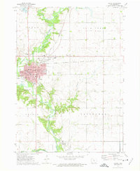
1972 Map of Algona
USGS Topo · Published 1975About this map
The East Fork Des Moines River winds through the heart of Kossuth County, defining the local geography as it flows past the county seat. In Algona, a dense network of civic and educational institutions is evident, including the Courthouse, St Cecelias Academy, and multiple local schools like Godfrey Sch and Wallace Sch. The town's layout reflects its role as a regional hub, featuring a concentrated business district and established residential areas buffered by the Fairground and several cemeteries, such as River View Cemetery and East Lawn Cem.
Find a feature on this map
38 named features on this map. Tap any name to fly to it.
Don’t see what you’re looking for? This feature index may not catch every label — zoom into the map to look around manually.
Map Details
Editions of this 1972 Algona Map
2 editions found
Other maps of this area

1954 · Fairmont
USGS Topo · 1:250,000

1954 · Fort Dodge
USGS Topo · 1:250,000

1957 · Fort Dodge
USGS Topo · 1:250,000

1958 · Fort Dodge
USGS Topo · 1:250,000

1958 · Fairmont
USGS Topo · 1:250,000

1972 · Algona
USGS Topo · 1:24,000

1972 · St. Joseph
USGS Topo · 1:24,000

1972 · Titonka
USGS Topo · 1:24,000

1972 · Burt
USGS Topo · 1:24,000
1972 · Sexton
USGS Topo · 1:24,000