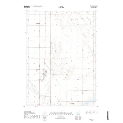
2018 Map of Bancroft
USGS Topo · Published 2018About this map
Bancroft serves as the central hub of this North Central Iowa landscape, situated at the intersection of a grid-like network of county roads and local avenues. The town's layout is clearly defined by its residential streets, including Oak St and E Kossuth St, alongside the local Po. South of the town center, genealogical interests are anchored by Saint Johns Cem and Greenwood Cem, which sit near the winding course of the East Fork Des Moines River. The surrounding terrain is characterized by agricultural drainage and natural waterways, notably Mud Cr and the engineered Drainage Ditch Number 80. In the southeast corner, the Smith Pool provides a distinct hydrological feature within the broader watershed of the Des Moines River system.
Find a feature on this map
50 named features on this map. Tap any name to fly to it.
Don’t see what you’re looking for? This feature index may not catch every label — zoom into the map to look around manually.
Map Details
Editions of this 2018 Bancroft Map
This is the sole edition of this map. No revisions or reprints were ever made.
Other maps of this area

1954 · Fairmont
USGS Topo · 1:250,000

1958 · Fairmont
USGS Topo · 1:250,000

1972 · German Valley
USGS Topo · 1:24,000

1972 · Bancroft
USGS Topo · 1:24,000

1972 · Titonka
USGS Topo · 1:24,000

1972 · Burt
USGS Topo · 1:24,000

1972 · Ledyard
USGS Topo · 1:24,000
1972 · Lakota
USGS Topo · 1:24,000

1980 · Lone Rock
USGS Topo · 1:24,000

1980 · Swea City
USGS Topo · 1:24,000