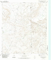
1983 Map of Bandera Mesa South
USGS Topo · Published 1984About this map
Tascotal Mesa and Bandera Mesa dominate this high-desert landscape in the Trans-Pecos, where the border of Presidio and Brewster Counties cuts through the high ground. The 1970s field data shows a remote ranching economy dependent on dispersed water sources, evidenced by the Shearing Pens Windmill and Pruit Windmill. Small cattle operations such as Bennett Ranch and Los Alamos Ranch are connected by a network of Jeep Trails and a central Landing Strip, illustrating the vast distances of West Texas. Drainage systems like Alamo de Cesario Creek and Ternéros Creek carve deep through the mesas, leading toward Fresno Creek in the south. Several natural springs, including Cottonwood Spring and Bee Spring, mark rare points of permanent water in an otherwise arid terrain of canyons and draws.
Find a feature on this map
32 named features on this map. Tap any name to fly to it.
Don’t see what you’re looking for? This feature index may not catch every label — zoom into the map to look around manually.
Map Details
Editions of this 1983 Bandera Mesa South Map
This is the sole edition of this map. No revisions or reprints were ever made.
Other maps of this area

1903 · Terlingua
USGS Topo · 1:125,000

1904 · Terlingua
USGS Topo · 1:125,000

1917 · Agua Fria
USGS Topo · 1:62,500

1917 · Tascotal Mesa
USGS Topo · 1:62,500

1931 · Lajitas
USGS Topo · 1:62,500

1937 · Agua Fria
USGS Topo · 1:62,500

1944 · Tascotal Mesa
USGS Topo · 1:62,500

1959 · Emory Peak
USGS Topo · 1:250,000

1965 · Emory Peak
USGS Topo · 1:250,000

1971 · Yellow Hill
USGS Topo · 1:24,000