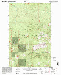
1997 Map of Banfield Mountain
USGS Topo · Published 2000About this map
Banfield Mountain and the high peaks of the Kootenai National Forest dominate this Lincoln County landscape as it appeared in the late 1990s. This region is a complex network of timber management and forest administration, divided among the Rexford Fisher River Ranger District, the Libby Fisher River Ranger District, and the Rexford Libby Ranger District. The topography is defined by significant drainage basins, including the South Fork Big Creek in the north and Libby Creek at the southern edge. Researchers will find the 8th Standard Parallel North bisecting the terrain near Lost Soul Mountain, while the secluded Blue Lake sits tucked into a high basin. The map detail reflects the intense surveying required to manage these public lands, showing the transition between various forest service jurisdictions across ridges like Lawrence Mountain.
Find a feature on this map
19 named features on this map. Tap any name to fly to it.
Don’t see what you’re looking for? This feature index may not catch every label — zoom into the map to look around manually.
Map Details
Editions of this 1997 Banfield Mountain Map
This is the sole edition of this map. No revisions or reprints were ever made.
Other maps of this area

1920 · Libby
USGS Topo · 1:125,000

1920 · Jennings
USGS Topo · 1:125,000

1930 · Libby
USGS Topo · 1:125,000

1932 · Libby
USGS Topo · 1:125,000

1935 · Thompson Lakes
USGS Topo · 1:96,000

1942 · Thompson Lakes
USGS Topo · 1:125,000

1957 · Kalispell
USGS Topo · 1:250,000

1960 · Kalispell
USGS Topo · 1:250,000

1961 · Kalispell
USGS Topo · 1:250,000

1963 · Vermiculite Mountain
USGS Topo · 1:24,000