1946 Map of Bangor
USGS Topo · Published 1946About this map
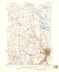
Bangor and its surrounding townships appear here at the conclusion of the second World War, showing a landscape defined by its major rail junctions and river frontage. The confluence of the Maine Central Railroad and the Bangor and Aroostook Railroad at Northern Maine Junction highlights the region's importance as a transportation hub for the Maine interior. Along the Penobscot River, the urban centers of Brewer and South Brewer face the primary settlement, while the outskirts reveal a more rural character through small hamlets like Leather Corner and Snow Corner. Significant military activity is noted at Dow Field and the adjacent U S Military Reservation, reflecting the era's defense priorities. The map also documents numerous recreational and domestic sites, from the landings on Pushaw Lake such as Elliot Landing and Sandy Beach, to local landmarks like the Longfellow Sch and Oak Grove Cem.
Find a feature on this map
96 named features on this map. Tap any name to fly to it.
Don’t see what you’re looking for? This feature index may not catch every label — zoom into the map to look around manually.
Map Details
Editions of this 1946 Bangor Map
3 editions found

Other maps of this area

1900 · Orland
USGS Topo · 1:62,500

1900 · Bucksport
USGS Topo · 1:62,500

1902 · Orono
USGS Topo · 1:62,500

1902 · Bucksport
USGS Topo · 1:62,500

1902 · Bangor
USGS Topo · 1:62,500

1917 · Passadumkeag
USGS Topo · 1:62,500

1931 · Stetson
USGS Topo · 1:48,000

1932 · Brooks
USGS Topo · 1:62,500

1932 · Dover-Foxcroft
USGS Topo · 1:48,000

1933 · Boyd Lake
USGS Topo · 1:62,500