
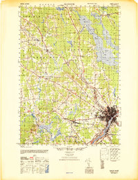
1946 Map of Bangor
USGS Topo · Published 1946About this map
The Penobscot River serves as the industrial and logistical anchor for this mid-1940s landscape, bordering the urban centers of Bangor and Brewer. The city’s strategic importance during this era is highlighted by the presence of Dow Field and the adjacent Military Reservation, while the complex rail network of the Maine Central Railroad converges at Northern Maine Junction.
Find a feature on this map
102 named features on this map. Tap any name to fly to it.
Don’t see what you’re looking for? This feature index may not catch every label — zoom into the map to look around manually.
Map Details
Editions of this 1946 Bangor Map
3 editions found
Other maps of this area

1900 · Orland
USGS Topo · 1:62,500

1900 · Bucksport
USGS Topo · 1:62,500

1902 · Orono
USGS Topo · 1:62,500

1902 · Bucksport
USGS Topo · 1:62,500

1902 · Bangor
USGS Topo · 1:62,500

1917 · Passadumkeag
USGS Topo · 1:62,500

1931 · Stetson
USGS Topo · 1:48,000

1932 · Brooks
USGS Topo · 1:62,500

1932 · Dover-Foxcroft
USGS Topo · 1:48,000

1933 · Boyd Lake
USGS Topo · 1:62,500