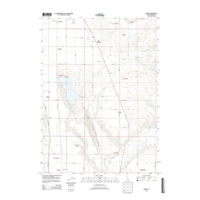
2013 Map of Banida
USGS Topo · Published 2013About this map
Banida and the surrounding agricultural landscape of Franklin County are defined by an intricate network of irrigation and water management features. The Treasureton Canal, Twin Lakes Canal, and W Cache Canal weave through the terrain, supporting the small settlements of Winder, Clifton, and Dayton. This rural corridor is also shaped by transportation and industry markers such as Dayton Siding and Beers Spur, which point to the region's historical reliance on rail for moving goods. Central to the geography are significant water bodies including Twin Lakes Reservoir, Strong Arm Reservoir, and Winder Reservoir, which anchor the local hydrography. The presence of Wayland Hot Springs near the Bear River in the south provides a distinct landmark amidst the varied elevations of Little Mtn and Poverty Flats, reflecting a landscape utilized for both its natural resources and its strategic position in the valley.
Find a feature on this map
91 named features on this map. Tap any name to fly to it.
Don’t see what you’re looking for? This feature index may not catch every label — zoom into the map to look around manually.
Map Details
Editions of this 2013 Banida Map
This is the sole edition of this map. No revisions or reprints were ever made.
Other maps of this area

1915 · Preston
USGS Topo · 1:96,000

1918 · Preston
USGS Topo · 1:125,000

1954 · Pocatello
USGS Topo · 1:250,000

1955 · Preston
USGS Topo · 1:250,000

1958 · Pocatello
USGS Topo · 1:250,000

1958 · Preston
USGS Topo · 1:250,000

1962 · Preston
USGS Topo · 1:250,000

1968 · Oxford
USGS Topo · 1:24,000

1968 · Clifton
USGS Topo · 1:24,000
1968 · Weston Canyon
USGS Topo · 1:24,000