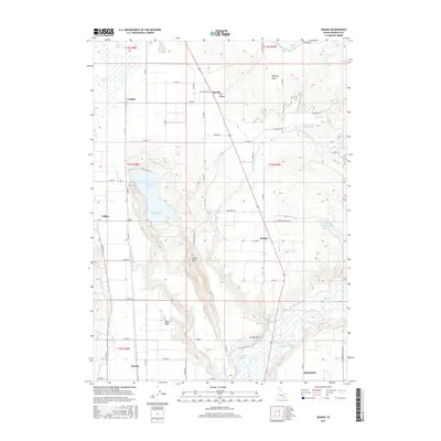
2017 Map of Banida
USGS Topo · Published 2017About this map
Banida and the surrounding agricultural lands of Franklin County are defined by a complex network of irrigation that supports this corner of the Cache Valley. The landscape is dominated by the Bear River and numerous reservoirs, including Twin Lakes Reservoir and Winder Reservoir, which supply the intricate Twin Lakes Canal system. This 2017 survey details the intersection of regional commerce and rural life, showing the proximity of Preston and Dayton to specialized landmarks like Wayland Hot Springs. Smaller settlements such as Winder, Clifton, and Coulam are connected by a grid of local roads and the legacy of the Beers Spur rail line. The terrain transitions from the marshy Oxford Slough to the higher ground of Little Mtn and the appropriately named Poverty Flats.
Find a feature on this map
49 named features on this map. Tap any name to fly to it.
Don’t see what you’re looking for? This feature index may not catch every label — zoom into the map to look around manually.
Map Details
Editions of this 2017 Banida Map
This is the sole edition of this map. No revisions or reprints were ever made.
Other maps of this area

1915 · Preston
USGS Topo · 1:96,000

1918 · Preston
USGS Topo · 1:125,000

1954 · Pocatello
USGS Topo · 1:250,000

1955 · Preston
USGS Topo · 1:250,000

1958 · Pocatello
USGS Topo · 1:250,000

1958 · Preston
USGS Topo · 1:250,000

1962 · Preston
USGS Topo · 1:250,000

1968 · Oxford
USGS Topo · 1:24,000

1968 · Clifton
USGS Topo · 1:24,000
1968 · Weston Canyon
USGS Topo · 1:24,000