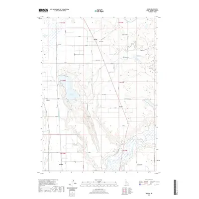
2020 Map of Banida
USGS Topo · Published 2020About this map
The Bear River corridor south of Preston anchors this 2020 landscape, where Idaho's agricultural heritage is etched into the terrain through a complex network of canals and reservoirs. The irrigation system, including the Twin Lakes Canal and W Cache Canal, supports several small rural communities such as Dayton, Clifton, and Banida. The map reveals a transition from the level floor of Poverty Flats to the rising elevations of Little Mtn, highlighting how settlement patterns follow the available water and the path of the river. Geothermal features like Wayland Hot Springs and water storage sites such as Twin Lakes Reservoir and Strong Arm Reservoir illustrate the area's diverse geological and hydrological profile. Local history is preserved in named landmarks like Beers Spur and Coulam, alongside thoroughfares such as Mail Route Rd and Fox Hollow Rd that link these agricultural outposts.
Find a feature on this map
45 named features on this map. Tap any name to fly to it.
Don’t see what you’re looking for? This feature index may not catch every label — zoom into the map to look around manually.
Map Details
Editions of this 2020 Banida Map
This is the sole edition of this map. No revisions or reprints were ever made.
Other maps of this area

1915 · Preston
USGS Topo · 1:96,000

1918 · Preston
USGS Topo · 1:125,000

1954 · Pocatello
USGS Topo · 1:250,000

1955 · Preston
USGS Topo · 1:250,000

1958 · Pocatello
USGS Topo · 1:250,000

1958 · Preston
USGS Topo · 1:250,000

1962 · Preston
USGS Topo · 1:250,000

1968 · Oxford
USGS Topo · 1:24,000

1968 · Clifton
USGS Topo · 1:24,000
1968 · Weston Canyon
USGS Topo · 1:24,000