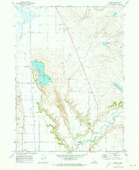
1969 Map of Banida
USGS Topo · Published 1973About this map
Union Pacific rail lines and an intricate network of irrigation canals define this portion of Franklin County in the late 1960s. The landscape is characterized by the contrast between the marshy Oxford Slough and the agricultural utility of the Twin Lakes Canal system. Small rural hubs like Banida, Dayton, and Winder are mapped alongside critical infrastructure including a grain elevator, pumping stations, and a radio facility near the Twin Lakes Reservoir.
Find a feature on this map
34 named features on this map. Tap any name to fly to it.
Don’t see what you’re looking for? This feature index may not catch every label — zoom into the map to look around manually.
Map Details
Editions of this 1969 Banida Map
This is the sole edition of this map. No revisions or reprints were ever made.
Other maps of this area

1915 · Preston
USGS Topo · 1:96,000

1918 · Preston
USGS Topo · 1:125,000

1954 · Pocatello
USGS Topo · 1:250,000

1955 · Preston
USGS Topo · 1:250,000

1958 · Pocatello
USGS Topo · 1:250,000

1958 · Preston
USGS Topo · 1:250,000

1962 · Preston
USGS Topo · 1:250,000

1968 · Oxford
USGS Topo · 1:24,000

1968 · Clifton
USGS Topo · 1:24,000
1968 · Weston Canyon
USGS Topo · 1:24,000