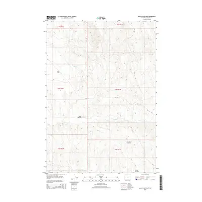
2015 Map of Banjo Flats East
USGS Topo · Published 2015About this map
Banjo Flats characterizes the high Wyoming basin terrain documented in this 2015 survey of Washakie County. The landscape is defined by its drainage patterns, most notably the seasonal watercourses of E Fork Nowater Cr and Little Slick Cr. The map reveals a land utilized for industrial and ranching purposes, signaled by the presence of Mobil Rd and Marconi Rd cutting across the undulating topography. Notable depressions like Denver Jake Draw and Little Denver Jake Draw provide significant local landmarks in an otherwise open range. These named features reflect a history of local navigation and land use in a region where water sources like Sand Cr are critical markers for anyone traversing the interior plains.
Find a feature on this map
14 named features on this map. Tap any name to fly to it.
Don’t see what you’re looking for? This feature index may not catch every label — zoom into the map to look around manually.
Map Details
Editions of this 2015 Banjo Flats East Map
This is the sole edition of this map. No revisions or reprints were ever made.
Other maps of this area

1955 · Sheridan
USGS Topo · 1:250,000

1955 · Arminto
USGS Topo · 1:250,000

1958 · Sheridan
USGS Topo · 1:250,000

1958 · Arminto
USGS Topo · 1:250,000

1962 · Sheridan
USGS Topo · 1:250,000

1962 · Arminto
USGS Topo · 1:250,000
1966 · Zimmerman Buttes
USGS Topo · 1:24,000
1966 · Banjo Flats West
USGS Topo · 1:24,000

1966 · Cabin Fork
USGS Topo · 1:24,000

1966 · Wagon Prong
USGS Topo · 1:24,000