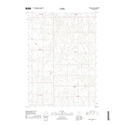
2017 Map of Banjo Flats East
USGS Topo · Published 2017About this map
Banjo Flats and the surrounding drainage basins of Washakie County define this high-desert landscape in northern Wyoming. The area is characterized by significant natural topographic depressions and seasonal watercourses, most notably the Denver Jake Draw and Little Denver Jake Draw. These features, along with E Fork Nowater Cr, provide a look at the complex hydrology of the Big Horn Basin. Human imprint on the land is primarily represented by industrial and utility access routes like Mobil Rd and Marconi Rd, reflecting the region's history of resource management. The map also traces the winding path of Little Slick Cr and Sand Cr, offering a detailed view of the terrain within the T45N through T47N township boundaries.
Find a feature on this map
15 named features on this map. Tap any name to fly to it.
Don’t see what you’re looking for? This feature index may not catch every label — zoom into the map to look around manually.
Map Details
Editions of this 2017 Banjo Flats East Map
This is the sole edition of this map. No revisions or reprints were ever made.
Other maps of this area

1955 · Sheridan
USGS Topo · 1:250,000

1955 · Arminto
USGS Topo · 1:250,000

1958 · Sheridan
USGS Topo · 1:250,000

1958 · Arminto
USGS Topo · 1:250,000

1962 · Sheridan
USGS Topo · 1:250,000

1962 · Arminto
USGS Topo · 1:250,000
1966 · Zimmerman Buttes
USGS Topo · 1:24,000
1966 · Banjo Flats West
USGS Topo · 1:24,000

1966 · Cabin Fork
USGS Topo · 1:24,000

1966 · Wagon Prong
USGS Topo · 1:24,000