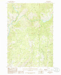
1985 Map of Banks
USGS Topo · Published 1986About this map
The confluence of the North Fork Payette River and its numerous mountain tributaries defines this portion of the Boise National Forest in the mid-1980s. The small settlement of Banks serves as a focal point where the river curves through the canyon, while the named locality of Zimmer sits further north along the bank. The landscape is dominated by high-elevation terrain, including Boise Mountain and the area designated as Charters, illustrating a region primarily characterized by its drainage network and forest management. Numerous family-named or descriptive waterways such as Fleming Creek, Pumpkin Creek, and Hill Creek cut through the steep topography, providing a detailed record of the local hydrologic nomenclature. This provisional edition preserves the specific locations of these creeks and small landings before later development or forest changes altered the accessible backcountry.
Find a feature on this map
16 named features on this map. Tap any name to fly to it.
Don’t see what you’re looking for? This feature index may not catch every label — zoom into the map to look around manually.
Map Details
Editions of this 1985 Banks Map
This is the sole edition of this map. No revisions or reprints were ever made.
Other maps of this area

1892 · Boise
USGS Topo · 1:125,000

1894 · Squaw Creek
USGS Topo · 1:125,000

1894 · Idaho Basin
USGS Topo · 1:125,000

1897 · Boise
USGS Topo · 1:125,000
1909 · Garden Valley
USGS Topo · 1:125,000
1953 · Banks
USGS Topo · 1:62,500

1955 · Baker
USGS Topo · 1:250,000

1955 · Hailey
USGS Topo · 1:250,000

1955 · Boise
USGS Topo · 1:250,000
1957 · Horseshoe Bend
USGS Topo · 1:24,000