
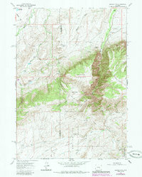
1960 Map of Banner Mtn
USGS Topo · Published 1965About this map
Medicine Bow National Forest dominates the southern reaches of this landscape, where the rugged terrain of Banner Mountain and Hess Hill meets the drainages of Deer Creek. The map documents a sparsely settled ranching region straddling the boundary between Natrona and Converse counties in the early 1960s. Family-named outposts and operations such as Smith Ranch, Rissler Ranch, and Davis Ranch are linked by primitive routes like Negro Creek Road and Skeen Road. The presence of the Banner Landing Strip near Banner Ranch suggests the logistical reliance on aviation in these isolated Wyoming highlands. Water management for livestock and homesteading is evident through features like Rissler Reservoir and McDonald Reservoir, situated near the confluence of canyon draws and seasonal creeks.
Find a feature on this map
43 named features on this map. Tap any name to fly to it.
Don’t see what you’re looking for? This feature index may not catch every label — zoom into the map to look around manually.
Map Details
Editions of this 1960 Banner Mtn Map
2 editions found
Other maps of this area

1949 · Brookhurst
USGS Topo · 1:24,000

1949 · Parkerton
USGS Topo · 1:24,000

1950 · Lockett
USGS Topo · 1:24,000

1950 · Brookhurst
USGS Topo · 1:24,000

1950 · Parkerton
USGS Topo · 1:24,000

1954 · Torrington
USGS Topo · 1:250,000

1955 · Casper
USGS Topo · 1:250,000

1958 · Casper
USGS Topo · 1:250,000

1958 · Torrington
USGS Topo · 1:250,000

1960 · Ice Cave Mountain
USGS Topo · 1:24,000