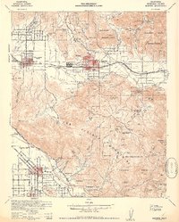
1942 Map of Banning
USGS Topo · Published 1952About this map
Morongo Indian Reservation and the Soboba Indian Reservation anchor this 1940s landscape, illustrating the proximity of tribal lands to the burgeoning towns of Banning and Beaumont. The presence of the St Boniface Indian Sch and the Banning Ranger Station highlights the administrative and social infrastructure of the era, while the Southern Pacific tracks through the San Gorgonio Pass define the region's transport corridor.
Find a feature on this map
75 named features on this map. Tap any name to fly to it.
Don’t see what you’re looking for? This feature index may not catch every label — zoom into the map to look around manually.
Map Details
Editions of this 1942 Banning Map
2 editions found
Other maps of this area

1899 · Redlands
USGS Topo · 1:62,500

1901 · Southern California Sheet No. 1
USGS Topo · 1:250,000

1901 · San Jacinto
USGS Topo · 1:125,000

1901 · Redlands
USGS Topo · 1:62,500

1901 · Elsinore
USGS Topo · 1:125,000

1902 · San Gorgonio
USGS Topo · 1:125,000

1904 · Southern California Sheet No. 1
USGS Topo · 1:250,000

1940 · Palm Springs
USGS Topo · 1:62,500

1940 · Hemet Reservoir
USGS Topo · 1:62,500

1942 · Banning
USGS Topo · 1:62,500