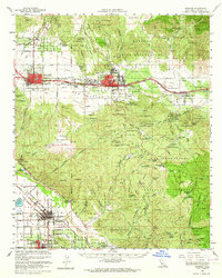
1956 Map of Banning
USGS Topo · Published 1964About this map
Banning and Beaumont serve as the primary hubs along the Southern Pacific line in this 1956 survey of the San Gorgonio Pass. The map illustrates a landscape shaped by critical water infrastructure, featuring the sprawling routes of the Colorado River Aqueduct and the San Diego Aqueduct as they cut through the mountains toward the coastal basins. The region’s mid-century character is defined by a mix of agricultural settlements like Cherry Valley and noted retreats such as Soboba Hot Springs and Gilman Hot Springs.
Find a feature on this map
70 named features on this map. Tap any name to fly to it.
Don’t see what you’re looking for? This feature index may not catch every label — zoom into the map to look around manually.
Map Details
Editions of this 1956 Banning Map
2 editions found
Other maps of this area

1899 · Redlands
USGS Topo · 1:62,500

1901 · Southern California Sheet No. 1
USGS Topo · 1:250,000

1901 · San Jacinto
USGS Topo · 1:125,000

1901 · Redlands
USGS Topo · 1:62,500

1901 · Elsinore
USGS Topo · 1:125,000

1902 · San Gorgonio
USGS Topo · 1:125,000

1904 · Southern California Sheet No. 1
USGS Topo · 1:250,000

1940 · Palm Springs
USGS Topo · 1:62,500

1940 · Hemet Reservoir
USGS Topo · 1:62,500

1942 · Banning
USGS Topo · 1:62,500