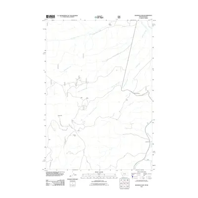
2011 Map of Bannock Pass
USGS Topo · Published 2011About this map
Bannock Pass serves as a critical point on the Continental Divide along the border of Montana and Idaho, marking a historic crossing in the Bitterroot Range. This 2011 survey illustrates a landscape defined by its complex drainage systems, where Horse Prairie Creek and Nip and Tuck Creek flow through the northern reaches. The area's topography is dominated by prominent elevations such as Grizzly Hill and deep carved features like Black Canyon. Transportation through this high-altitude corridor is anchored by Railroad Canyon Rd, which follows the natural path of Canyon Creek toward the pass. Small-scale topographical details, including Mollies Gulch and Hood Gulch, provide specific points of interest for those studying the physical geography and ranching access routes of Beaverhead County.
Find a feature on this map
13 named features on this map. Tap any name to fly to it.
Don’t see what you’re looking for? This feature index may not catch every label — zoom into the map to look around manually.
Map Details
Editions of this 2011 Bannock Pass Map
This is the sole edition of this map. No revisions or reprints were ever made.
Other maps of this area

1955 · Dubois
USGS Topo · 1:250,000

1956 · Leadore
USGS Topo · 1:62,500

1956 · Morrison Lake
USGS Topo · 1:62,500

1958 · Dubois
USGS Topo · 1:250,000

1965 · Deadman Pass
USGS Topo · 1:24,000

1965 · Jeff Davis Peak
USGS Topo · 1:24,000

1965 · Lemhi Pass
USGS Topo · 1:24,000
1965 · Everson Creek
USGS Topo · 1:24,000

1965 · Bannock Pass
USGS Topo · 1:24,000
1965 · Goat Mountain
USGS Topo · 1:24,000