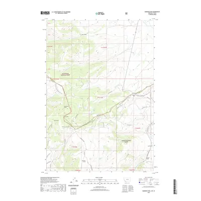
2020 Map of Bannock Pass
USGS Topo · Published 2020About this map
Bannock Pass serves as a critical point on the high ridge line separating the Beaverhead National Forest in Montana from the Salmon National Forest in Idaho. This 2020 map documents the complex topography of the Continental Divide, where the Continental Divide National Scenic Trail winds through high-altitude terrain including Grizzly Hill and Jakes Canyon. The map reveals a network of primitive roads and trails that follow the natural drainage patterns of the Bitterroot Range, such as Railroad Canyon Rd and S Divide Creek Rd. Significant water sources are named throughout the high country, including Irish Boy Springs, Wagonbox Springs, and the headwaters of Horse Prairie Cr. The presence of the Nez Perce Nht (Nez Perce National Historic Trail) in the northeast corner highlights the area's deep connection to Indigenous travel routes across the divide.
Find a feature on this map
54 named features on this map. Tap any name to fly to it.
Don’t see what you’re looking for? This feature index may not catch every label — zoom into the map to look around manually.
Map Details
Editions of this 2020 Bannock Pass Map
This is the sole edition of this map. No revisions or reprints were ever made.
Other maps of this area

1955 · Dubois
USGS Topo · 1:250,000

1956 · Leadore
USGS Topo · 1:62,500

1956 · Morrison Lake
USGS Topo · 1:62,500

1958 · Dubois
USGS Topo · 1:250,000

1965 · Deadman Pass
USGS Topo · 1:24,000

1965 · Jeff Davis Peak
USGS Topo · 1:24,000

1965 · Lemhi Pass
USGS Topo · 1:24,000
1965 · Everson Creek
USGS Topo · 1:24,000

1965 · Bannock Pass
USGS Topo · 1:24,000
1965 · Goat Mountain
USGS Topo · 1:24,000