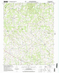
2002 Map of Banoak
USGS Topo · Published 2003About this map
Cat Square and Hulls Crossroads anchor the southern reaches of this landscape, where the rural character of the Piedmont is defined by a dense network of country churches and family-named cemeteries. The terrain is marked by significant elevations like Lynn Mtn and Brandle Mtn, while the drainage of Jacob Fork and Indian Creek shapes the settlement patterns between Catawba and Lincoln counties. Small communities such as Banoak, Henry, and Vale are linked by winding secondary roads, reflecting a long history of agricultural subsistence and local commerce.
Find a feature on this map
36 named features on this map. Tap any name to fly to it.
Don’t see what you’re looking for? This feature index may not catch every label — zoom into the map to look around manually.
Map Details
Editions of this 2002 Banoak Map
This is the sole edition of this map. No revisions or reprints were ever made.
Other maps of this area

1895 · Hickory
USGS Topo · 1:125,000

1905 · Morganton
USGS Topo · 1:125,000

1909 · Lincolnton
USGS Topo · 1:62,500

1911 · Lincolnton
USGS Topo · 1:62,500

1950 · Shelby
USGS Topo · 1:62,500

1953 · Charlotte
USGS Topo · 1:250,000

1954 · Charlotte
USGS Topo · 1:250,000

1956 · Valdese
USGS Topo · 1:24,000

1956 · Casar
USGS Topo · 1:24,000

1960 · Charlotte
USGS Topo · 1:250,000