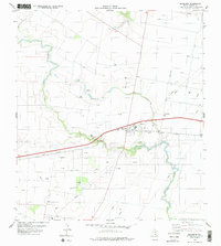
1979 Map of Banquete
USGS Topo · Published 1979About this map
Banquete sits at the heart of this Nueces County landscape, where the agricultural traditions of the Texas Coastal Bend meet the intensive energy production of the late 1970s. The settlement is defined by its position along the Texas Mexican line, a critical rail corridor flanked by grain Storage Bins and an Athletic Field. Beyond the town center, the terrain is a dense network of industrial activity, marked by hundreds of Oil Well and Gas Well sites that dot the fields between the meandering paths of Agua Dulce Creek and Petronila Creek. This period reveals a landscape in transition, where community spaces like Sabiadura Park and the local Cem exist alongside a sprawling infrastructure of pipelines, a Landing Strip, and a prominent Radio Tower. The survey captures the functional character of a rural Texas hub supporting both the ranching legacy of the region and the mid-century petroleum boom.
Find a feature on this map
20 named features on this map. Tap any name to fly to it.
Don’t see what you’re looking for? This feature index may not catch every label — zoom into the map to look around manually.
Map Details
Editions of this 1979 Banquete Map
This is the sole edition of this map. No revisions or reprints were ever made.
Other maps of this area

1924 · Petronilla
USGS Topo · 1:62,500

1925 · Robstown
USGS Topo · 1:62,500

1950 · Corpus Christi
USGS Topo · 1:250,000

1954 · Orange Grove
USGS Topo · 1:62,500

1954 · Robstown
USGS Topo · 1:62,500

1954 · Kingsville
USGS Topo · 1:62,500

1954 · Petronila
USGS Topo · 1:62,500

1956 · Corpus Christi
USGS Topo · 1:250,000

1960 · Corpus Christi
USGS Topo · 1:250,000

1966 · Corpus Christi
USGS Topo · 1:250,000