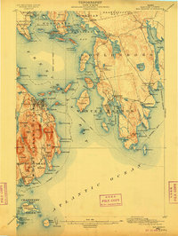
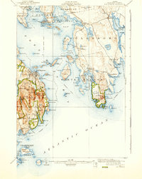
1904 Map of Bar Harbor
USGS Topo · Published 1909About this map
Frenchman Bay anchors this coastal landscape, serving as a primary maritime thoroughfare long before the modern tourism era. On Mount Desert Island, the village of Bar Harbor is shown with its intricate network of streets and piers, while the Maine Central RR terminates across the water at Mount Desert Ferry, marking a vital rail-to-steamer link for early travelers. The eastern shore is dominated by the Gouldsboro Peninsula, where small fishing and harbor settlements like Winter Harbor and Prospect Harbor line the coast. Farther south, the Cranberry Isles including Islesford and Sutton highlight the importance of offshore communities during the early twentieth century. The map illustrates a complex coastal economy dependent on established steamboat routes and natural harbors, before the widespread expansion of motorized land travel redefined the Maine coastline.
Find a feature on this map
166 named features on this map. Tap any name to fly to it.
Don’t see what you’re looking for? This feature index may not catch every label — zoom into the map to look around manually.
Map Details
Editions of this 1904 Bar Harbor Map
6 editions found
Other maps of this area

1902 · Cherryfield
USGS Topo · 1:62,500

1904 · Cherryfield
USGS Topo · 1:62,500

1904 · Mount Desert
USGS Topo · 1:62,500

1904 · Swan Island
USGS Topo · 1:62,500

1904 · Bar Harbor
USGS Topo · 1:62,500

1904 · Petit Manan
USGS Topo · 1:62,500

1911 · Ellsworth
USGS Topo · 1:62,500

1930 · Tunk Lake
USGS Topo · 1:48,000

1932 · Tunk Lake
USGS Topo · 1:62,500

1940 · Ellsworth
USGS Topo · 1:62,500