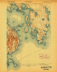
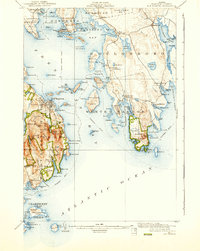
1904 Map of Bar Harbor
USGS Topo · Published 1920About this map
Bar Harbor serves as the central hub of Mount Desert Island in this early twentieth-century survey, a time when the region was transitioning into a premier maritime destination. The map details the early boundaries of Lafayette National Park, including prominent peaks like Cadillac Mt. and Flying Squadron Mt.. The landscape is defined by its intricate coastline, where the Maine Central R. R. terminates at Mount Desert Ferry, connecting rail travelers to the island's many harbors via steamboat routes.
Find a feature on this map
132 named features on this map. Tap any name to fly to it.
Don’t see what you’re looking for? This feature index may not catch every label — zoom into the map to look around manually.
Map Details
Editions of this 1904 Bar Harbor Map
6 editions found
Other maps of this area

1902 · Cherryfield
USGS Topo · 1:62,500

1904 · Cherryfield
USGS Topo · 1:62,500

1904 · Mount Desert
USGS Topo · 1:62,500

1904 · Swan Island
USGS Topo · 1:62,500

1904 · Bar Harbor
USGS Topo · 1:62,500

1904 · Petit Manan
USGS Topo · 1:62,500

1911 · Ellsworth
USGS Topo · 1:62,500

1930 · Tunk Lake
USGS Topo · 1:48,000

1932 · Tunk Lake
USGS Topo · 1:62,500

1940 · Ellsworth
USGS Topo · 1:62,500