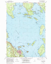
1982 Map of Bar Harbor
USGS Topo · Published 1983About this map
Bar Harbor serves as the focal point of this coastal survey, showing the town's densely developed street grid and maritime infrastructure in the early 1980s. The map illustrates the town's role as a regional hub, featuring institutions such as the College of the Atlantic, Holy Redeemer Ch, and the terminal for the Bar Harbor-Yarmouth, N.S. Ferry. To the west, the protected wilderness of Acadia National Park dominates the landscape with landmarks like Witch Hole Pond and New Mills Meadow Pond. Across the water, the peninsulas of Crabtree Neck and Waukeag Neck frame the northern reaches of Frenchman Bay. Smaller settlements like Sorrento and Hancock Point are documented alongside numerous islands, including the prominent Stave Island and Jordan Island, reflecting the complex geography of the Maine coastline before major modern expansions changed these seasonal and year-round communities.
Find a feature on this map
106 named features on this map. Tap any name to fly to it.
Don’t see what you’re looking for? This feature index may not catch every label — zoom into the map to look around manually.
Map Details
Editions of this 1982 Bar Harbor Map
2 editions found
Other maps of this area

1904 · Mount Desert
USGS Topo · 1:62,500

1904 · Bar Harbor
USGS Topo · 1:62,500

1911 · Ellsworth
USGS Topo · 1:62,500

1930 · Tunk Lake
USGS Topo · 1:48,000

1932 · Tunk Lake
USGS Topo · 1:62,500

1940 · Ellsworth
USGS Topo · 1:62,500

1942 · Bar Harbor
USGS Topo · 1:62,500

1942 · Ellsworth
USGS Topo · 1:62,500

1942 · Mount Desert
USGS Topo · 1:62,500

1942 · Tunk Lake
USGS Topo · 1:62,500