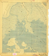
1892 Map of Barataria
USGS Topo · Published 1898About this map
Bayou Barataria serves as a central artery through this delta landscape in the final decade of the nineteenth century, where the boundaries of Jefferson, Plaquemines, and Lafourche parishes meet. This survey captures a hydrological network shaped by the winding Mississippi River and the expansive waters of Lake Ouacha or Salvador. The map reveals the early industrial footprint of the region via the N O F J & G I R R railroad, which cuts across the marshland.
Find a feature on this map
19 named features on this map. Tap any name to fly to it.
Don’t see what you’re looking for? This feature index may not catch every label — zoom into the map to look around manually.
Map Details
Editions of this 1892 Barataria Map
3 editions found
Other maps of this area

1891 · Hahnville
USGS Topo · 1:62,500

1891 · Pointe a La Hache
USGS Topo · 1:62,500

1891 · New Orleans
USGS Topo · 1:62,500

1892 · Barataria
USGS Topo · 1:62,500

1892 · Cut-Off
USGS Topo · 1:62,500

1892 · Creole
USGS Topo · 1:62,500

1892 · St. Bernard
USGS Topo · 1:62,500

1892 · Pointe a La Hache
USGS Topo · 1:62,500

1893 · Fort Livingston
USGS Topo · 1:62,500

1894 · Lake Felicity
USGS Topo · 1:62,500