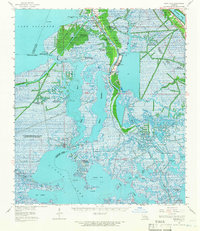
1962 Map of Barataria
USGS Topo · Published 1966About this map
The communities of Barataria and Lafitte anchor this mid-century survey of the Mississippi River Delta, where the land fragmentizes into a complex network of bayous and wetlands. The map documents an era of intense petroleum exploration, identifying numerous resource zones including the Lafitte Oil Field, the Manila Village Oil Field, and the West Delta Farms Oil Field. These industrial sites are interspersed among a landscape of tidal flats and marshes, where a notable "Line of demarcation between salt marsh and fresh marsh" is marked through the center of the sheet. For those tracing family histories, several burial grounds are recorded along the waterways, such as Fleming Cem, Coulon Cem, and Docard Cem. Local education and faith centers like Fisher Sch and Sacred Heart Ch serve as navigational landmarks within the intricate drainage of Bayou Perot, Bayou Rigolettes, and Little Lake.
Find a feature on this map
62 named features on this map. Tap any name to fly to it.
Don’t see what you’re looking for? This feature index may not catch every label — zoom into the map to look around manually.
Map Details
Editions of this 1962 Barataria Map
2 editions found
Other maps of this area

1891 · Hahnville
USGS Topo · 1:62,500

1891 · Pointe a La Hache
USGS Topo · 1:62,500

1891 · New Orleans
USGS Topo · 1:62,500

1892 · Barataria
USGS Topo · 1:62,500

1892 · Cut-Off
USGS Topo · 1:62,500

1892 · Creole
USGS Topo · 1:62,500

1892 · St. Bernard
USGS Topo · 1:62,500

1892 · Pointe a La Hache
USGS Topo · 1:62,500

1893 · Fort Livingston
USGS Topo · 1:62,500

1894 · Lake Felicity
USGS Topo · 1:62,500