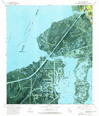
1973 Map of Barataria
USGS Topo · Published 1976About this map
The settlement of Barataria sits at the northern edge of this coastal landscape, marked by local community landmarks like St Anthony Ch and St John Ch. This 1970s orthophotomap reveals a transition in the Louisiana wetlands where natural bayous meet an extensive industrial infrastructure of the mid-20th century. The complex web of the Intracoastal Waterway and various man-made canals, such as the Paillet Canal and Dry Cypress Canal, segments the marshland to facilitate maritime transport and resource extraction.
Find a feature on this map
28 named features on this map. Tap any name to fly to it.
Don’t see what you’re looking for? This feature index may not catch every label — zoom into the map to look around manually.
Map Details
Editions of this 1973 Barataria Map
This is the sole edition of this map. No revisions or reprints were ever made.
Other maps of this area

1891 · Hahnville
USGS Topo · 1:62,500

1891 · New Orleans
USGS Topo · 1:62,500

1892 · Barataria
USGS Topo · 1:62,500

1892 · Cut-Off
USGS Topo · 1:62,500

1932 · New Orleans SE
USGS Topo · 1:31,680

1932 · New Orleans SW
USGS Topo · 1:31,680

1939 · Cut-Off
USGS Topo · 1:62,500
1940 · Bertrandville
USGS Topo · 1:31,680

1941 · Cut-Off
USGS Topo · 1:62,500

1941 · Barataria
USGS Topo · 1:62,500