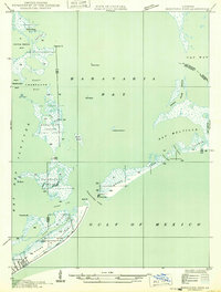
1949 Map of Barataria Pass
USGS Topo · Published 1949About this map
Ft Livingston stands as a sentinel overlooking Barataria Pass, marking a landscape defined by the shifting barrier islands of Jefferson Parish during the late 1940s. The settlement at Grand Isle is clearly delineated at the southwestern corner, showing the residential layout and State Highway No 620 before the significant coastal changes of the late 20th century. The map provides a detailed view of the complex waterway systems within Barataria Bay, including numerous bays like West Champagne Bay and East Champagne Bay. Notable navigational aids and landmarks such as the Barataria L. H. and various triangulation stations like Champagne 3 and Abel 2 are recorded, reflecting the area's importance for maritime traffic and military history. The intricate network of bayous, including Rigaud Bayou and Bayou Fifi, illustrates the delicate balance of this marshy coastal environment.
Find a feature on this map
42 named features on this map. Tap any name to fly to it.
Don’t see what you’re looking for? This feature index may not catch every label — zoom into the map to look around manually.
Map Details
Editions of this 1949 Barataria Pass Map
This is the sole edition of this map. No revisions or reprints were ever made.
Other maps of this area

1892 · Cheniere Caminada
USGS Topo · 1:62,500

1892 · Creole
USGS Topo · 1:62,500

1893 · Fort Livingston
USGS Topo · 1:62,500

1935 · Bay Ronquille
USGS Topo · 1:31,680

1935 · Wilkinson Bay
USGS Topo · 1:31,680

1945 · New Orleans
USGS Topo · 1:250,000

1947 · Caminada Pass
USGS Topo · 1:31,680

1947 · Bay Ronquille
USGS Topo · 1:31,680
1947 · Wilkinson Bay
USGS Topo · 1:31,680
1948 · Fort Livingston
USGS Topo · 1:62,500