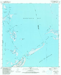
1993 Map of Barataria Pass
USGS Topo · Published 1994About this map
Grand Isle and its surrounding marshlands represent the delicate frontier between the Louisiana coastline and the Gulf of Mexico. This 1993 revision, based on surveys from the early 1970s and 1990s, documents a landscape shaped by both military history and modern industry. The Ft Livingston Ruins stand on the edge of the Grand Terre Islands, guarding the entry to Barataria Pass, while the Queen Bess Island Oil and Gas Field indicates the region's significant economic activity.
Find a feature on this map
41 named features on this map. Tap any name to fly to it.
Don’t see what you’re looking for? This feature index may not catch every label — zoom into the map to look around manually.
Map Details
Editions of this 1993 Barataria Pass Map
This is the sole edition of this map. No revisions or reprints were ever made.
Other maps of this area

1892 · Cheniere Caminada
USGS Topo · 1:62,500

1892 · Creole
USGS Topo · 1:62,500

1893 · Fort Livingston
USGS Topo · 1:62,500

1935 · Bay Ronquille
USGS Topo · 1:31,680

1935 · Wilkinson Bay
USGS Topo · 1:31,680

1945 · New Orleans
USGS Topo · 1:250,000

1947 · Caminada Pass
USGS Topo · 1:31,680

1947 · Bay Ronquille
USGS Topo · 1:31,680
1947 · Wilkinson Bay
USGS Topo · 1:31,680
1948 · Fort Livingston
USGS Topo · 1:62,500