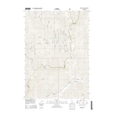
2013 Map of Barber Flat
USGS Topo · Published 2013About this map
The North Fork Boise River and Middle Fork Boise River converge within this high-elevation landscape, defining the rugged geography of the Boise National Forest. Remote recreational sites like the Black Rock Campground and Ninemeyer Campground are tucked into the drainages of the Boise Mountains, where numerous small tributaries like Crooked River and Rabbit Cr feed the larger river system. The presence of Barber Flat and Alexander Flats suggests rare level ground amidst steep canyon walls and ridges, including the prominent Hungarian Ridge. This 2013 survey illustrates the complex drainage patterns and Forest Service infrastructure that support access to this backcountry area, tracing timber and recreational routes like Road Creek Rd through the Boise and Elmore county line.
Find a feature on this map
43 named features on this map. Tap any name to fly to it.
Don’t see what you’re looking for? This feature index may not catch every label — zoom into the map to look around manually.
Map Details
Editions of this 2013 Barber Flat Map
This is the sole edition of this map. No revisions or reprints were ever made.
Other maps of this area

1894 · Idaho Basin
USGS Topo · 1:125,000

1894 · Rocky Bar
USGS Topo · 1:125,000

1955 · Hailey
USGS Topo · 1:250,000

1959 · Hailey
USGS Topo · 1:250,000

1962 · Hailey
USGS Topo · 1:250,000

1964 · Little Trinity Lake
USGS Topo · 1:24,000

1964 · Sheep Creek
USGS Topo · 1:24,000

1964 · Twin Springs
USGS Topo · 1:24,000
1972 · Rabbit Creek Summit
USGS Topo · 1:24,000
1972 · Barber Flat
USGS Topo · 1:24,000